Introduction:
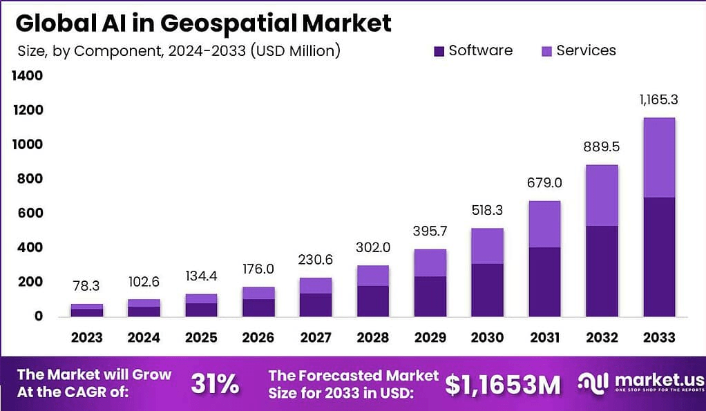
The AI in geospatial market is projected to surpass USD 15 billion by 2030, growing at a CAGR of over 13% from 2024 to 2030. This growth is fueled by increasing demand for real-time location analytics, smart city planning, and precision agriculture. Government agencies, urban planners, and private enterprises are integrating AI with GIS (Geographic Information Systems) for faster data interpretation and automated decision-making. The demand impact is evident in critical sectors like defense, disaster response, and infrastructure development, where AI enhances prediction accuracy, resource allocation, and situational awareness using satellite and aerial imagery.
Key Takeaways:
- Market size to exceed USD 15 billion by 2030
- CAGR expected at 13% between 2024–2030
- Demand driven by smart cities, defense, and climate monitoring
- AI improves image classification and spatial pattern detection
- GIS and AI integration streamlines real-time decision-making
- High adoption in agriculture and urban development
- North America leads; APAC shows rapid growth
- Demand for predictive geospatial analytics rising
- Cloud-based platforms accelerate AI geospatial adoption
- Accuracy and processing speed significantly enhanced
Emerging Trends:
Emerging trends include the fusion of AI with LiDAR and drone technology for advanced terrain mapping and environmental surveillance. Deep learning models are improving feature extraction from satellite imagery, enabling automated land use classification. The rise of digital twins and 3D geospatial models, powered by AI, is revolutionizing urban planning. Cloud-native geospatial platforms with AI capabilities are growing, allowing scalable and real-time analytics. AI is also being applied to detect climate anomalies and monitor deforestation. The integration of edge AI in field sensors and mobile geospatial devices is enabling faster and decentralized spatial intelligence at the point of data collection.
Use Cases:
- Urban planning: AI analyzes satellite imagery for zoning, infrastructure, and land use
- Precision agriculture: Enhances crop monitoring, yield prediction, and soil health analysis
- Disaster response: Supports damage assessment and resource deployment post-events
- Climate monitoring: Detects patterns in temperature, rainfall, and vegetation change
- Defense and surveillance: Automates threat detection and terrain analysis
- Transport optimization: Improves traffic management and logistics routing
- Telecom planning: Assists in optimal tower placement using spatial demand forecasting
- Utilities and energy: Manages grid infrastructure and renewable resource potential mapping
Major Challenges:
Despite its promise, the AI in geospatial market faces key challenges. High costs of satellite data acquisition and processing can limit accessibility for smaller organizations. Data privacy concerns arise with surveillance and location tracking. Model accuracy is highly dependent on data quality, and inaccuracies can lead to flawed insights. There’s a shortage of skilled professionals proficient in both AI and geospatial technologies. Regulatory hurdles, particularly in defense and cross-border data sharing, pose compliance issues. Integration with legacy GIS systems can be complex and resource-intensive. Additionally, ensuring real-time performance with high-resolution datasets remains technically demanding.
Opportunities:
Opportunities in AI for geospatial applications are vast. Government smart city initiatives globally are creating demand for AI-enabled urban analytics. In agriculture, AI-driven geospatial tools are transforming food security and resource management. The expansion of 5G networks offers new use cases in location intelligence for telecom. There’s rising interest in AI-powered environmental monitoring for carbon tracking and conservation. Emergency response agencies are turning to geospatial AI for proactive disaster risk reduction. Advancements in sensor technologies, combined with edge AI, are opening new markets in mining, marine, and forestry sectors. Startups and open-source tools are also democratizing access to geospatial AI.
Key Players Analysis:
Leading players in the AI in geospatial market focus on integrating machine learning, computer vision, and natural language processing with GIS and remote sensing platforms. They offer AI-powered geospatial analytics solutions tailored to industries such as agriculture, defense, utilities, and urban planning. Innovation focuses on real-time object detection, predictive mapping, and automated image interpretation. These companies are also investing in scalable cloud infrastructures, enhancing interoperability with third-party geospatial datasets. Strategic collaborations with satellite imaging providers and AI chipmakers strengthen their market positions. Emphasis is placed on ease of use, customization, and providing AI insights at the edge.
Conclusion:
AI is transforming geospatial analysis by automating data processing, improving prediction accuracy, and enabling smarter, faster decisions. With strong demand across public and private sectors, the market offers immense potential for innovation and societal impact. While challenges around cost, integration, and privacy persist, ongoing technological advancements and supportive policies are paving the way for AI-driven spatial intelligence. As global reliance on location-based insights deepens, AI in geospatial applications is poised to become a cornerstone of data-driven decision-making across industries.
The macro analyst desk brings highly sought after financial news based on market analysis, insider news and company filings.